A New Horizon for Gujarat: The Kalpasar Project and the Quest for Water Security
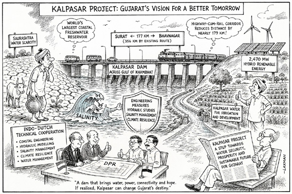
The Gulf of Khambhat, long characterized by its treacherous tides and immense energy potential, is poised to become the site of one of the most ambitious engineering feats in modern history. The Kalpasar Project—a colossal proposal to create the world’s largest coastal freshwater reservoir—promises to fundamentally reshape the hydrological and economic landscape of Gujarat. By damming the Gulf, the project aims to transform a saline marine environment into a massive freshwater basin, effectively turning a region historically plagued by water scarcity into a surplus-driven powerhouse.
For decades, the Saurashtra region has grappled with the twin challenges of recurring drought and groundwater depletion. As agricultural demands intensify and climate patterns become increasingly erratic, the reliance on monsoon-dependent water sources has proven insufficient. The Kalpasar Project is designed to act as a permanent, reliable buffer, capturing the massive inflow of freshwater from rivers such as the Narmada, Mahi, and Sabarmati before they reach the sea. By preventing this vital resource from being lost to the Arabian Gulf, the project seeks to establish a sustainable water supply that could sustain both intensive agriculture and expanding industrial hubs for generations to come.
Engineering a Multi-Modal Economic Corridor
Beyond its primary function as a water reservoir, the Kalpasar Project carries a significant secondary objective: the creation of a massive highway-cum-rail corridor across the Gulf. This infrastructure component is designed to bridge the geographic divide between the Bhavnagar and Surat districts, effectively shrinking the travel distance between these two critical economic zones by nearly 180 kilometers.
This connectivity is expected to unlock unprecedented potential for trade, logistics, and tourism. By creating a direct link across the Gulf, the project will bypass the circuitous overland routes that currently hinder the efficient movement of goods from the Saurashtra peninsula to the industrial clusters of South Gujarat. This reduction in logistics costs is anticipated to attract significant investment, fostering a more integrated regional economy. Furthermore, the construction of this corridor serves as a catalyst for local development, providing small-scale farmers and businesses with faster access to major markets and export hubs, thereby modernizing the regional supply chain.
Global Expertise and Climate Resilience
The complexity of damming a high-tidal estuary requires world-class technical precision. To ensure the viability and safety of the structure, the project has leveraged an Indo-Dutch collaboration, drawing on the Netherlands’ centuries-old expertise in coastal engineering and water management. Dutch engineers, renowned for their mastery of land reclamation and dike construction, are providing critical input into the Detailed Project Report (DPR). This partnership focuses on incorporating cutting-edge climate resilience strategies, ensuring that the reservoir can withstand the pressures of rising sea levels and shifting sedimentation patterns.
By integrating international best practices in hydrology and coastal defense, the project aims to mitigate environmental risks, such as saltwater intrusion and the potential disruption of marine ecosystems. This collaborative approach underscores the gravity of the project, positioning it not just as a local water management scheme, but as a global model for how coastal nations can adapt to the challenges of climate change while simultaneously driving economic growth.
What This Means for Farmers
For the agricultural community in Saurashtra and surrounding districts, the Kalpasar Project represents a fundamental shift in risk management and production capacity. The practical implications include:
- Stabilized Irrigation Cycles: The creation of a vast freshwater reservoir will provide a consistent, year-round water supply, reducing the vulnerability of Kharif and Rabi crops to monsoon failures. This predictability allows for long-term crop planning and the potential for increased multi-cropping.
- Recharge of Groundwater Tables: The presence of a massive freshwater body adjacent to land is expected to facilitate the natural recharge of aquifers. This could lead to a rise in water levels in existing borewells, reducing the energy costs associated with deep-well pumping.
- Mitigation of Soil Salinity: In coastal areas where saltwater intrusion has historically degraded soil fertility, the influx of freshwater will help flush out salts and improve soil health, potentially opening up previously uncultivable land for high-value agricultural production.
- Improved Logistics and Market Access: The new highway-cum-rail corridor will drastically reduce the time and cost required to transport perishable produce to urban centers and ports. Farmers will gain more competitive access to both domestic and international markets, potentially increasing their profit margins by reducing post-harvest losses and transit times.
While the project remains a long-term undertaking, its completion would mark the end of the "water-stressed" era for the region. For farmers, the transition from scarcity to surplus is not merely an engineering milestone—it is a pathway to greater financial autonomy and modernized, climate-resilient agriculture.